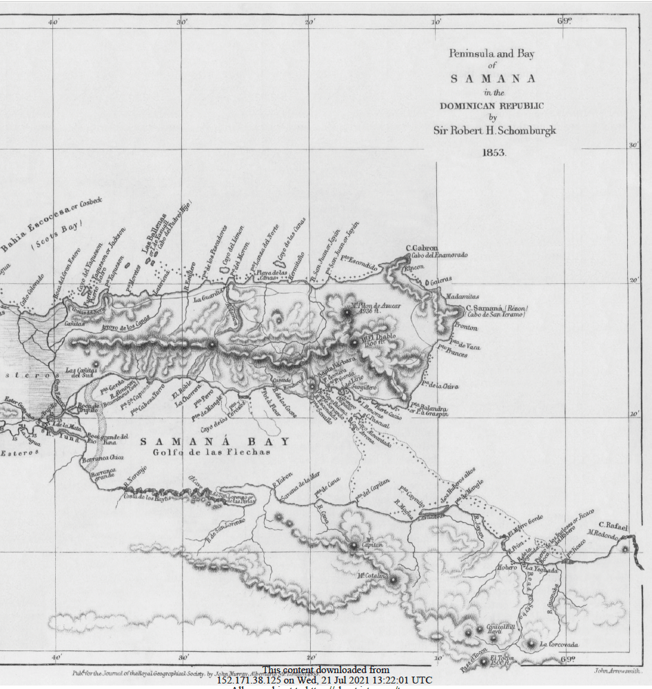
I recently came across a document I could not put down: a report on the Samaná Peninsula written in 1853 by Sir Robert H. Schomburgk, Britain’s consul in the Dominican Republic, and read before the Royal Geographical Society in London on 13 June that year. It was published in the society’s journal (the original is archived on JSTOR).
Almost two centuries later, I live and build on this same peninsula. So reading how a Victorian diplomat described it was a strange mix of familiar and unrecognizable. Here is what stood out to me.
A peninsula that kept changing flags
Schomburgk opens with history, and Samaná’s is crowded. Columbus sailed past in January 1493 and named the headland now known as Cabo Cabrón “Cabo del Enamorado”, the Lover’s Cape. He anchored in the great bay, where a skirmish with the local Ciguayo people, said to be the first bloodshed between Europeans and natives in the New World, earned it the name Golfo de las Flechas, the Gulf of Arrows. Schomburgk also notes the cacique’s name, Cayacoa, and corrects Washington Irving on it.
From there the story gets busier:
- 1670s: French buccaneers and settlers from Tortuga, under governor d’Ogeron, built a thriving colony of indigo growers. The vessel carrying young women meant for Tortuga put in at Samaná instead, and the master sold them there, a detail Schomburgk relays with some amusement.
- 1700: After a surprise Spanish attack from Cotuí and an order from the French government, the settlement was abandoned.
- 1756: Spain sent colonists from the Canary Islands (the Isleños) and founded Santa Bárbara de Samaná.
- 1802: Napoleon’s fleet of more than 60 vessels, under General Leclerc, chose Samaná Bay as its rendezvous on the way to retake Santo Domingo. Toussaint Louverture, on hearing it, rode there in haste.
- 1808–1809: A British squadron helped Dominican patriots take Fort Santa Bárbara from the French.
- 1822: Haiti annexed the east of the island, and another French fleet appeared in the bay.
- 1844: Dominican independence, followed in 1850 by Britain being the first power to recognize the young republic in a formal treaty.
Few places of this size sat at the center of so many rivalries between empires. That alone says something about the value others saw in it.
An island that almost was one
Schomburgk measured the peninsula at 32 miles from west to east, about 225 square miles in area, with a coastline of roughly 95 miles. Old maps even drew it as a separate island. He gathered the evidence: at the start of the 19th century, flat-bottomed boats from Samaná sailed through the Gran Estero, a channel across the low, swampy isthmus, to reach northern ports like Puerto Plata and Montecristi without rounding the stormy Cape Samaná. By his time the channel had silted up and mangroves grew over its mouth, but he thought it could easily be reopened.
The mountain he called the Sugar-loaf near Cabo Cabrón stood at 1,936 feet, and the Montaña del Diablo at 1,300.
The bay, the reefs and the pirate
The great bay runs some 30 miles to the mouth of the Yuna river. Schomburgk found it well protected: a long reef, with the Banister Cays at its eastern end, shields the basin from the Atlantic gales. That protection cut both ways. Two Spanish galleons were lost on the reefs in 1724, and a French 74-gun ship was wrecked near Punta Jicaco.
The cays take their name from Jack Banister, an English pirate who at the end of the 17th century put his guns ashore on one of them. When two English frigates tried to force the passage, his crews killed more than 120 of the attackers and drove the rest off. Schomburgk says the navies of the world could shelter in the bay and that its creeks could hold arsenals and docks.
He also surveyed the Yuna himself in August 1851, sounding the river by boat. His verdict: highly fertile banks, few people, and swarms of mosquitoes. A sandy bar at the mouth blocked proper navigation, but he thought engineering could make the river navigable for steamers, a “high-road” to La Vega, the Cibao and the Maimón mining district.
The caves of the Bay of Pearls
My favorite part is the geology. In the Bahía de San Lorenzo, which Columbus called the Bay of Pearls, Schomburgk found dozens of conical limestone hills, 80 to 150 feet high, rising from the water “like beehives”. He compared them to the villages of native tribes he had seen in Guiana. Today this area is part of Los Haitises, and he even explains the name: Haiti was, he writes, the Indian word for hill.
Inside one of the hills he explored a great cave about 150 feet long with a roof reaching 70 feet. He describes stalagmites that his imagination turned into an Achilles on a pedestal and a gazelle, fresh water pooling in the rock, a giant fig tree sending roots down to the cave floor, and a second chamber full of bats that nearly put out their torches.
He found Indian figures carved into the rock, enormous heaps of shell (so large that the streets of Sabana de la Mar had been paved with them), and a piece of urn-shaped pottery he thought might have been a musical instrument. He closes the visit with an image I find hard to forget: the evening waves entering the caves and making a sound that “imagination” could take for the lament of the vanished Taíno.
Coal, mahogany and the best coffee
On resources, he was an optimist. Mahogany (caoba) was the peninsula’s greatest export, growing wild in the mountain forests, alongside other cabinet and shipbuilding timbers. He reported bituminous coal near the Almacén stream, plus traces of copper and gold, and said the lack of real investigation was down to neglect, not geology.
On agriculture he was almost wistful. The soil was “highly productive”, the fruit trees so loaded in mango season that he found the fruit rotting under them, and he was convinced that Samaná coffee would rival the best from Martinique or Jamaica. Yams from Samaná, he noted, were the best in the country and sold for one and a half to two dollars a barrel.
A small, multilingual town
The population in 1851 was 1,721 people, in a town of about ninety houses and huts. What I did not expect: roughly 300 of them were Americans and their descendants, free Black emigrants who had arrived in 1824 during the Haitian period and had a Wesleyan chapel and school of their own. Riding to the Coco river, Schomburgk was addressed in three languages by the people he met: English, Spanish and French. He praised the Americans for the cleanliness of their provision grounds and their industry.
Commerce ran mostly to the Turks Islands, which depended on Samaná and Puerto Plata for vegetables, cattle and poultry. He did not hide his disappointment at the state of Santa Bárbara itself, a “picture of decay”, and put the blame on how few people there were to work such good land.
His conclusion: the head of the bridge
Schomburgk ends with a strategic argument. Samaná lies to windward of Jamaica, Cuba and the Gulf of Mexico, almost due northeast of the isthmus of Central America, which in the 1850s was attracting the attention of the world as the route between the Atlantic and the Pacific. Quoting a French author, he calls the bay la tête du pont, the head of the bridge to the highway between the two oceans. Its fertile soil, deep anchorages and forests for shipbuilding were only half the case; its position was the real prize.
What I take from it
Reading it 173 years later, three things strike me. First, the fundamentals he describes have not moved: the bay, the climate, the soil, the forests, the caves, the geography that made empires want it. Second, he kept coming back to the same complaint, that a place with this much going for it was held back by how few people were investing in it. Third, he saw its future in connection to the wider world, not in isolation.
Samaná today looks very different from his Santa Bárbara of ninety huts. But anyone who has stood on the water in the bay at sunset will recognize what he was writing about.
Source: R. H. Schomburgk, “The Peninsula and Bay of Samaná, in the Dominican Republic”, Journal of the Royal Geographical Society of London, vol. 23 (1853), pp. 264–283. jstor.org/stable/1797968



Leave a Reply